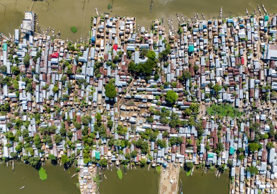
Big data kilder er blevet brugt til at sammensætte et massivt og globalt dækkende kort over skove og deres forvaltning. Kortets potentiale er uendeligt.
Global Forest Watch and developed over several years with more than 40 partners, draws from a rich array of “big data” related to the word’s forests and translates it into interactive maps and charts that reveal trends in deforestation, forest recovery, and industrial forestry expansion. Global Forest Watch is the first tool to monitor global forests on a monthly basis, allowing authorities and conservationists to potentially take action against deforestation as it is occurring, Mongabay.com writes Thursday.
“Businesses, governments and communities desperately want better information about forests. Now, they have it,” said Andrew Steer, WRI President and CEO, in a statement. “Global Forest Watch is a near-real time monitoring platform that will fundamentally change the way people and businesses manage forests. From now on, the bad guys cannot hide and the good guys will be recognized for their stewardship.”
Google teknologi hjælper med at bearbejde de kolosale datamængder
Global Forest Watch leverages Google’s computing cloud to make sense of staggering amounts of NASA satellite data, which in the past would have taken years to process, according to Rebecca Moore, Engineering Manager at Google Earth Outreach and Earth Engine, who worked with a team of researchers led by University of Maryland scientist Matt Hansen to develop the high resolution dataset of forest cover and change that underpins the system.
“[To produce that databaset] we analyzed… almost 700,000 Landsat images,” Moore said. “It was a total of 20 terra-pixels of Landsat data and to do that we applied one million CPU hours on 10,000 computers in parallel in order to run Dr. Hansen’s models to characterize forest cover and change. It would have taken a single computer 15 years to perform this analysis that we completed in a matter of days using the Google Earth Engine technology.”
Få en mail om fare for afskovning
The result is a high resolution map that reveals annual change in forest cover since 2000. Global Forest Watch integrates data from other sources to generate near-real time alerts akin to the system Brazil has used to help reduce deforestation by nearly 80 percent since 2004. Users — whether they be government authorities, conservationists, members of traditional forest communities, activists, or armchair environmentalists — can set up personalized alerts to generate emails whenever there are signs of deforestation in an area, including municipalities, national parks, or zones defined by the user drawing shapes on a map.
“Technical users can download the data for their own analysis,” said Nigel Sizer, director of the Global Forest Project. “But a cool function for everyone is the alert system, which automatically sends you alerts telling you when there is forest cover change in the area you specify.”
De mere end bare rumlige data kan også bruges politisk
Global Forest Watch however goes well beyond displaying forest cover and change data. In several countries, WRI has persuaded governments to release spatial data on forestry concessions, including oil palm, timber, and pulp and paper plantations in Indonesia, a country which until now has been notorious for lack of transparency in its forestry sector. Global Forest Watch lists each concession in the country, including the owner and permit information. That data can be used as a layer to see how fast oil palm plantations have expanded at the expense of natural forests and even pinpoint cases where illegal conversion has occurred within protected areas. For example, the map shows oil palm development in two nature reserves — Gunung Nuit Penrisen and Gunung Raya Pasi — in Indonesia’s West Kalimantan. Global Forest Watch also has extensive concession data for Congo Basin countries, Liberia, and Colombia. Further data will be added as it is becomes available.
The concession data could prove especially useful to companies who have committed to eliminating deforestation from their supply chains.
“It’s going to help our suppliers demonstrate that they are indeed also free of deforestation,” said Duncan Pollard of Nestle, which launched a zero deforestation policy for palm oil sourcing in 2010. “And it’s going to help us monitor and report on the progress that we make on to our global commitment.”
“Deforestation poses a material risk to businesses that rely on forest-linked crops. Exposure to that risk has the potential to undermine the future of businesses,” added Paul Polman, CEO of Unilever, in a statement. “As we strive to increase the visibility of where the ingredients for our products come from, the launch of Global Forest Watch – a fantastic, innovative tool – will provide the information we urgently need to make the right decisions, fostering transparency, enforcing accountability, and facilitating partnerships.”
Read the rest of the story here on Mongabay.com.